
6.方法测试
在这个部分我们要整体的测试我们的程序,对前面的知识和内容有一个整体的应用和概括。
这是Udacity提供的相应资料,在code文件夹中有一个Rover_Project_Test_Notebook.ipynb文件,提供了输出视频的笔记本文件。
由于个人喜好的原因,我选择了pycharm2019来运行此程序。
(1)方法测试程序概述
在这个部分我们需要完成的项目如下
首先运行笔记本中的每个单元格,检查代码和每个单元格的结果。
在“训练模式”中运行模拟器并记录一些数据。注意:只需要使用一些示例图像,几百张即可。
将数据目录路径(下面的2个单元格)更改为保存数据的目录
测试数据上提供的功能
编写新功能(或修改现有功能)以报告和绘制障碍物和岩石样本(黄色岩石)的检测结果
使用适当的步骤/函数填充process_image()函数,以从原图像转换为worldmap。
使用moviepy函数运行调用process_image()的单元格以创建视频输出
如果绘制工作可以进行,则继续修改perception.py和decision.py,让流浪者号自主导航并以自动模式进行绘制。
首先我们需要获取ffmpeg工具
import imageio

imageio.plugins.ffmpeg.download()
运行此程序以下载ffmpeg工具。
但我在运行这个程序时遇到了一个问题。
报错
imageio.ffmpeg.download() has been deprecated. Use 'pip install imageio-ffmpeg' instead.'‘
经查阅,该错误是由版本更新引起的错误,解决办法(在Windows上)为
pip install imageio==2.4.1
现在再一次运行我们的程序,如果imageio正确安装且电脑中没有安装ffmpeg,程序会自动下载安装
import imageio

imageio.plugins.ffmpeg.download()
python会自动下载ffmpeg,如果下载不成功或者速度太慢可以选择到相应网站下载,单击这里进行下载。
ffmpeg应当放到AppData目录下。
(2)读入以保存的数据和世界地图
我们定义一个名为 Databucket() 类来存储测量数据、图像路径和图像。
当我们实例化这个类时,我们将得到一个名为 data 的全局变量,我们将在之后的 process_image() 函数中来引用其中的数据。
其程序如下:
import pandas as pd
df = pd.read_csv('.../Roversim/Roverdata/robot_log.csv', delimiter=';', decimal='.')
csv_img_list = df["Path"].tolist()
# 读入世界地图并使用它创建一个3通道的图像
ground_truth = mpimg.imread('.../RoboND-Rover-Project-master/calibration_images/map_bw.png')
ground_truth_3d = np.dstack((ground_truth*0, ground_truth*255, ground_truth*0)).astype(np.float)

# 创建一个类作为Databucket,读取csv文件中保存的数据并填充此对象。
# worldmap被实例化为200*200个网格,其对应200m*200m的空间。
class Databucket():
    def __init__(self):
        self.images = csv_img_list
        self.xpos = df["X_Position"].values
        self.ypos = df["Y_Position"].values
        self.yaw = df["Yaw"].values
        self.count = 0 # 运行索引
        self.worldmap = np.zeros((200, 200, 3)).astype(np.float)
        self.ground_truth = ground_truth_3d # Ground truth worldmap

# 实例化一个databucket,这将是一个全局变量,
# 我们可以在接下来的process_image()函数中使用
data = Databucket()
(3)图像处理函数
1)process_image()函数
编写process_image()函数,以执行图像分析和映射。我们只需要把对应漫游者号的位置等映射到worldmap上去就可以。
在之前的程序中,我们小车的位置和偏转角是随机生成的,但是这里就需要我们来读取csv文件中的数据,将相应的透视变换之后的图像映射到世界地图上去。
换句话说, 我们将各个图像传递到 process_image() 函数并以此来构建一个名为 output_image 的图像,该图像将存储为视频的一帧。
下面是经过更改后的 process_image() 函数:
# 定义图片处理函数
def process_image(img):
   output_image = np.zeros((img.shape[0] + data.worldmap.shape[0],img.shape[1] * 2, 3))
   # 定义第一张图为img
   output_image[0:img.shape[0], 0:img.shape[1]] = img

   # 定义第二张图为img经过透视变换后的图像
   warped = perspect_transform(img, src, dst)
   output_image[0:img.shape[0], img.shape[1]:] = warped

   gray_warped = cv2.cvtColor(warped, cv2.COLOR_RGB2GRAY)
   ret, img_thresh = cv2.threshold(gray_warped, 160, 255, cv2.THRESH_BINARY)
   test_image = np.expand_dims(img_thresh, axis=2)
   output_image[180:340, img.shape[1]:, 0] = img_thresh

   xpix, ypix = rover_coords(img_thresh)
   worldmap = data.worldmap
   x_world, y_world = pix_to_world(xpix, ypix, data.xpos[data.count], data.ypos[data.count], data.yaw[data.count],
                                   data.worldmap.shape[0], 20 )
   worldmap[y_world, x_world] += 1

   map_add = cv2.addWeighted(ground_truth_3d, 1, worldmap, 0.2, 0)
   output_image[img.shape[0]:, 0:data.worldmap.shape[1]] = map_add

   cv2.putText(output_image, "Test!", (20, 20),
               cv2.FONT_HERSHEY_COMPLEX, 0.4, (255, 255, 255), 1)
   # 跟踪Databucket中的索引
   if data.count < len(data.images) - 1:
       data.count += 1

   return output_image
2)cv2.addWeighted
此函数是为了使两个图像叠加使用的,用在我们将小车的透视变换后的图像映射到世界地图上。
dst = cv2.addWeighted(src1, alpha, src2, beta, gamma[, dst[, dtype]])
参数说明:
src1 - 第一个输入数组。
alpha - 第一个数组元素的权重。
src2 - 与src1具有相同大小和通道编号的第二个输入数组。
beta - 第二个数组元素的权重。
dst - 与输入数组具有相同大小和通道数的输出数组。
gamma - 标量加到每个总和。
dtype - 输出数组的可选深度; 当两个输入数组具有相同的深度时,dtype可以设置为-1,这相当于src1.depth()
此函数可以用一下矩阵表达式来代替:
dst = src1 * alpha + src2 * beta + gamma;
(4)输出测试视频
因为我们要对特定的颜色进行图像颜色阈值处理,比如之后选择特定的黄色的岩石样本,所以我图像二值化选择使用numpy来完成而不是cv2。其程序如下:
def color_thresh(img, rgb_thresh=(160, 160, 160)):
    color_select = np.zeros_like(img[:,:,0])
    above_thresh = (img[:,:,0] > rgb_thresh[0]) \
                & (img[:,:,1] > rgb_thresh[1]) \
                & (img[:,:,2] > rgb_thresh[2])
    color_select[above_thresh] = 1
    return color_select

threshed = color_thresh(warped)
plt.imshow(threshed, cmap='gray')
以下是最终程序
import numpy as np
import cv2
import pandas as pd
import matplotlib.image as mpimg
from moviepy.editor import VideoFileClip
from moviepy.editor import ImageSequenceClip


##颜色阈值
# 使用Numpy定义二值化图像函数
def color_thresh(img, rgb_thresh=(160, 160, 160)):
    img_thresh = np.zeros_like(img[:, :, 0])
    above_thresh = (img[:, :, 0] > rgb_thresh[0]) \
                   & (img[:, :, 1] > rgb_thresh[1]) \
                   & (img[:, :, 2] > rgb_thresh[2])
    img_thresh[above_thresh] = 1

    return img_thresh


##透视变换
# 定义图像映射函数,将摄像头的图像映射到平面坐标中去
def perspect_transform(img, src, dst):
    M = cv2.getPerspectiveTransform(src, dst)  # 定义变换矩阵
    img_perspect = cv2.warpPerspective(img, M, (img.shape[1], img.shape[0]))
    return img_perspect


##坐标变换
# 定义从图像坐标转换函数
def rover_coords(binary_img):
    ypos, xpos = binary_img.nonzero()
    x_pixel = -(ypos - binary_img.shape[0]).astype(np.float)
    y_pixel = -(xpos - binary_img.shape[1]/2 ).astype(np.float)
    return x_pixel, y_pixel


# 定义旋转操作函数
def rotate_pix(xpix, ypix, yaw):
    yaw_rad = yaw * np.pi / 180
    xpix_rotated = (xpix * np.cos(yaw_rad)) - (ypix * np.sin(yaw_rad))
    ypix_rotated = (xpix * np.sin(yaw_rad)) + (ypix * np.cos(yaw_rad))
    return xpix_rotated, ypix_rotated


# 定义平移操作函数
def translate_pix(xpix_rot, ypix_rot, xpos, ypos, scale):
    xpix_translated = (xpix_rot / scale) + xpos
    ypix_translated = (ypix_rot / scale) + ypos
    return xpix_translated, ypix_translated


# 定义综合函数,将旋转和平移函数进行结合,并限制了图像范围
def pix_to_world(xpix, ypix, xpos, ypos, yaw, world_size, scale):
    xpix_rot, ypix_rot = rotate_pix(xpix, ypix, yaw)
    xpix_tran, ypix_tran = translate_pix(xpix_rot, ypix_rot, xpos, ypos, scale)
    x_pix_world = np.clip(np.int_(xpix_tran), 0, world_size - 1)
    y_pix_world = np.clip(np.int_(ypix_tran), 0, world_size - 1)
    return x_pix_world, y_pix_world


# 定义转换为极坐标函数
def to_polar_coords(xpix, ypix):
    dist = np.sqrt(xpix**2 + ypix ** 2)
    angles = np.arctan2(ypix, xpix)
    return dist, angles

# 参考图像,用作透视变换
filename = '.../RoboND-Rover-Project-master/calibration_images/example_grid1.jpg'
image = cv2.imread(filename)

dst_size = 5
bottom_offset = 0

src = np.float32([[14, 140], [301, 140], [200, 96], [118, 96]])
dst = np.float32([[image.shape[1]/2 - dst_size, image.shape[0] - bottom_offset],
                  [image.shape[1]/2 + dst_size, image.shape[0] - bottom_offset],
                  [image.shape[1]/2 + dst_size, image.shape[0] - 2*dst_size - bottom_offset],
                  [image.shape[1]/2 - dst_size, image.shape[0] - 2*dst_size - bottom_offset],
                  ])

# 透视变换
warped = perspect_transform(image, src, dst)

df = pd.read_csv('.../Roverdata/robot_log.csv', delimiter=';', decimal='.')
csv_img_list = df["Path"].tolist() # 创建一个关于图像的路径列表
# 读取worldmap,并创建一个三维图像
ground_truth = mpimg.imread('.../RoboND-Rover-Project-master/calibration_images/map_bw.png')
ground_truth_3d = np.dstack((ground_truth*0, ground_truth*255, ground_truth*0)).astype(np.float)


# 定义一个类来存储诸如漫游者号位置,方向角等数据
class Databucket():
    def __init__(self):
        self.images = csv_img_list
        self.xpos = df["X_Position"].values
        self.ypos = df["Y_Position"].values
        self.yaw = df["Yaw"].values
        self.count = 0
        self.worldmap = np.zeros((200, 200, 3)).astype(np.float)
        self.ground_truth = ground_truth_3d

# 实例化Databucket类
data = Databucket()


# 定义图片处理函数
def process_image(img):
    output_image = np.zeros((img.shape[0] + data.worldmap.shape[0],img.shape[1] * 2, 3))
    # 定义第一张图为摄像头原图img
    output_image[0:img.shape[0], 0:img.shape[1]] = img

    # 定义第二张图为img经过透视变换后的图像
    warped = perspect_transform(img, src, dst)
    output_image[0:img.shape[0], img.shape[1]:] = warped

    gray_warped = cv2.cvtColor(warped, cv2.COLOR_RGB2GRAY)
    ret, img_thresh = cv2.threshold(gray_warped, 160, 255, cv2.THRESH_BINARY)
    test_image = np.expand_dims(img_thresh, axis=2)
    output_image[180:340, img.shape[1]:, 0] = img_thresh

	# 漫游者号的坐标系,在每一个图像中都不同
    xpix, ypix = rover_coords(img_thresh)
    worldmap = data.worldmap
    x_world, y_world = pix_to_world(xpix, ypix, data.xpos[data.count], data.ypos[data.count], data.yaw[data.count], data.worldmap.shape[0], 20 )
    # 相应位置颜色+1
    worldmap[y_world, x_world] += 1

    map_add = cv2.addWeighted(ground_truth_3d, 1, worldmap, 0.2, 0)
    output_image[img.shape[0]:, 0:data.worldmap.shape[1]] = map_add

    cv2.putText(output_image, "Test_Video", (20, 20),
                cv2.FONT_HERSHEY_COMPLEX, 0.4, (255, 255, 255), 1)
    # 跟踪Databucket中的索引
    if data.count < len(data.images) - 1:
        data.count += 1

    return output_image

# 将处理过的图像制作成视频,使用moviepy
output = '.../test_mapping.mp4'

clip = ImageSequenceClip(data.images, fps=60)
new_clip = clip.fl_image(process_image)# 只接受彩色图片
new_clip.write_videofile(output, audio=False)
输出的视频结果如下: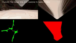


评论(0)
您还未登录,请登录后发表或查看评论